Sunday, August 6, 2006

2006.35.50 - Cadboro Bay to Willows Beach: There and Back Again

With our ducks all in a row, we head out.
IMGP1165

Soon after launch, we are overflown by some geese. We expect that later we will be overflown by some snowbirds.
IMGP1160

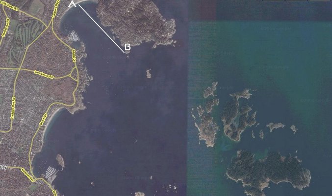
The plan is to put in at Cadboro Bay (A). From there we'll head out out along the south side of 10 Mile Point to Flower Island (B). Here we'll check the currents and see what's what. Eventually, we'll head south towards Willows Beach.

We start out with a large group: Alan, Louise, Bernie...IMGP1163
...Lenora, Paula and Dennis. And that's me taking the picture.
IMGP1164

Ahead is Flower Island...
IMGP1169
...where we stopped to check the lay of the land. Or the wave of the water, I guess.
IMGP1171

We decided to head out to Jemmy Jones Island.
IMGP1174
From Jemmy Jones Island (C), Bernie was hoping to continue straight out to the Chain Islands but the currents were fast and unpredictable today and many of us felt like we were getting in a little over our heads. And if you're getting in over your head in a kayak, that probably means that you're underwater. Never a good thing in a kayak.
IMGP1176

So we regrouped....
IMGP1178
...and headed back to shore to head south to Willows Beach.
IMGP1185

Beautiful weather, not a cloud in the sky. Perfect bird-watching weather. I'm sure we'll see some.
IMGP1187
Blue

We followed the shore around Cattle Point and put in at Willows Beach (D).
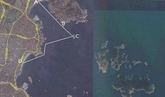

We didn't see any cows at Cattle Point, but we did see a couple of otters. They "otter" have named it Otter Point.
IMGP1194

We put in on the beach. Dennis and Lenora returned to Cadboro Bay, and Alan had a brief stop on the beach, then he too returned to Cadboro Bay.
IMGP1199

Mmmmm... food!
IMGP1200

The beach is totally packed. Thousands of people. You'd think that there's gonna be some sort of airshow by the world-famous Snowbirds precision aerobatic team or something.
IMGP1203

Bernie's figured out a perfect way to watch the Snowbirds.
Bring Your Own Chair
No, wait. He's looking at this cool boat with "pedal-paddles."
IMGP1207

Behind the tree on the right is Mary Tod Island. That's were we plan to put in and watch the show.
IMGP1205

I've never seen Willows Beach this crowded... officials estimated that 30,000 people were on the shore. It's funny how police and officials always over-estimate crowds at conventional events like this, but usually under-estimate crowds at anti-war rallies and anti-globization marches. But I digress.
IMGP1212

Here the Victoria Police chopper tries to get some boats out of the safety zone. Victoria has a police chopper? Who knew?
IMGP1216
Here the Victoria Police Boat patrols the safety zone. Victoria has a police boat? Who knew?
IMGP1214

We paddled out to Mary Tod Island (E). The red line turned out to be the Snowbirds' two solo pilots' flight path. They were flying right over our heads.
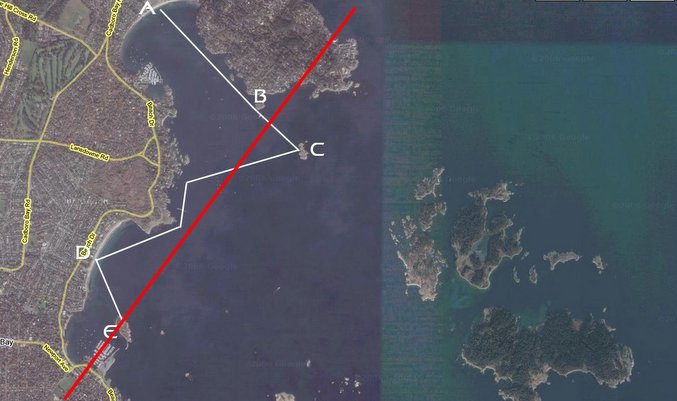

Here they come...
DSC02091
DSC02097
DSC02067
DSC02092
DSC02086
DSC02094
DSC02047.0

Back in the water for the paddle back to Cadboro Bay.
IMGP1218

We're starting to understand all these nautical symbols. These one means "Warning: Red Triangles Ahead."
IMGP1220

There were plenty of people enjoying a great day on the water, and in the sky. Another fun paddle is done.
IMGP1223

My pictures are here.

Sunday, July 30, 2006

2006.34.49 - Saanich Inlet Crossing

If we're in our kayaks, it must be Sunday! Our first cloudy day in a number of weeks greets us as we put in. We didn't have a specific plan, as we weren't sure about the weather. It had rained heavily overnight and the rain was still threatening. But there were some breaks in the clouds.
IMGP1087

Bernie's paddle does not get off to a promising start as he got into his boat backwards.
IMGP1091

We put in at the Brentwood Bay Ferry Terminal (point A). We decided to try our first crossing of Saanich Inlet to Bamberton, an old cement plant on the shore (north of point B). We had also talked about doing a day trip down Finlayson Arm one day, so we decided to head south down the Arm after we had crossed to see what this area was like.


And away we go! Bernie starts by playing in the ferry's wake.
IMGP1094

He also wanted to make sure we were going the right way. (Note that he's still backwards in his kayak. Ha, just kidding! Gotcha!)
IMGP1097

Louise sets the pace...
IMGP1099
... and Paula keeps up.
IMGP1101

Now we're out in the Saanich Inlet proper. Ahead of us is the cement plant. We knew that winds were going to be rising over the course of the day and we figured that we might be somewhat sheltered from them by the hills around the Inlet. That theory didn't work out though, as the winds came up and grew stronger during our crossing.
IMGP1104

We stuck together and paddled on.
IMGP1103

It took us about 30-35 minutes to get across the Inlet. We came in a little south of the cement works (point B).
IMGP1108

We went south along the coast. The winds continued rising and it was a battle.
IMGP1110

Louise doesn't seem to have noticed the seal to her right.
IMGP1111

We saw a few other seal moms with their pups in this spot, but the water was rough and the pictures didn't turn out very well, alas. Below are a moms and her pup, one near the center and another on the left edge.
IMGP1118

Mind you, the pictures of the eagles fared a little better. There's two in the tree ahead of Paula.
IMGP1120
Eagle

After taking the last picture of the eagle, he flew off. I had turned my kayak around to get the shot and was facing backwards to our direction of travel. I realized that I was surrounded by seals. They were popping up all over the place. I slowly started to paddle backwards and I discovered they were following me. I kept paddling backwards and they kept popping up quickly then ducking beneath the waves. There must have been at least a dozen of them. It was like "Whack-a-mole" except that they were seals and I didn't have a mallet. Eventually, they stopped following and I turned around and caught up to the group at point C, when we decided that the winds and the waves were getting a little much. We had to cross the Inlet at some point to return home...
IMGP1132
...so we turned and began our crossing.
Then the Wind Came Up...

It looks rough, and, well, it was. But with the wind and the waves at our back now, the paddling was pretty easy. But we still has to careful that we kept in line with waves so that they wouldn't broadside us.
Rough Crossing

How windy is it? Check out the flag behind Louise.
WIndy Paddle

We rounded point D back into Brentwood Bay, much less open than Saanich Inlet, and the waves and wind died right down. The rest of the paddle was calm and peaceful.
IMGP1137

We went down into Tod Inlet...
IMGP1143
...and put in at point E...
IMGP1144
...for food! Paula and Bernie brought along some wrap fixings. It sure hit the spot.
IMGP1147

After a little break, we continued down Tod Inlet...
IMGP1154
...until we reached the end (point F).
Paddling Down Tod Inlet

As we came back, Bernie discovered a cave-like thing. Maybe it's a cave.
IMGP1156

Finally, another great paddle comes to end.
Alone

My pictures are here.